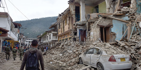
Security cameras and citizen reports captured the shocking moment the shaking began and the immediate damage caused across the country’s on the country’s infrastructure.
Aug. 10, 2026, will be remembered as a day of profound tragedy and resilience for the Colombian people. At 7:34 a.m., a violent 7.4-magnitude earthquake shook the western and central regions of the country, interrupting the start of the workday for millions of citizens and sparking panic in major cities. The quake—considered the most powerful recorded in the nation in recent decades—has claimed the lives of at least 224 people and left more than 2,500 injured, according to the latest official reports.
The Epicenter of the Crisis
According to the Colombian Geological Service (SGC), the epicenter was located in the municipality of San José del Palmar, in the department of Chocó, at a depth of approximately 96 to 103 kilometers. Due to geological factors, the seismic waves covered an exceptionally wide area, extending outward and heavily impacting distant regions. The earthquake was felt for between 90 and 120 seconds—a duration residents described as “an eternity” of panic and uncertainty.
Assessment of Regional Destruction
The structural impact has been devastating, with over 1,500 homes affected and dozens of buildings suffering total collapse:
*Pereira: This area sustained the most severe humanitarian impact, reporting residential collapses and significant damage to the Matecaña Airport terminal.
*Cali: A critical situation unfolded in the El Limonar neighborhood and at medical centers, where healthcare staff were forced to conduct emergency patient evacuations amidst collapsing structures.
*Coffee Axis and Chocó: Municipalities such as Salento, Quibdó, and El Cairo suffered the loss of architectural heritage and extensive damage to building facades and churches.
*National Road Network: San José del Palmar was cut off by land due to multiple landslides that blocked the delivery of aid.
State Response and International Support
Given the magnitude of the catastrophe, the President of the Republic, Abelardo de la Espriella, immediately declared a state of national disaster and emergency to expedite the deployment of rescue resources. Relief agencies, firefighters, and the National Army are working against the clock to clear debris and search for survivors. International solidarity was swift; regional governments, such as that of El Salvador, dispatched planes carrying tons of humanitarian aid to support relief efforts for those affected.
Dos Mundos Co-editor Héctor Pérez, who is currently vacationing in Cali, Colombia, described the earthquake as
“an eternal movement; it seemed like it would never end—it lasted a long time.”
El terremoto que paralizó a Colombia
Las cámaras de seguridad y reportes ciudadanos registraron el impactante momento del movimiento y los estragos inmediatos en la infraestructura del país.
El 10 de agosto de 2026 quedará marcado como una fecha de profunda tragedia y resiliencia para el pueblo colombiano. A las 07:34 a. m., un violento terremoto de magnitud 7.4 sacudió con fuerza el occidente y centro del país, interrumpiendo el inicio de la jornada laboral de millones de ciudadanos y sembrando el pánico en las principales capitales. El sismo, considerado el más potente registrado en la nación en las últimas décadas, ha cobrado la vida de al menos 224 personas y ha dejado a más de 2.500 heridos, según los reportes oficiales más recientes.
El epicentro de la emergencia
De acuerdo con el Servicio Geológico Colombiano (SGC), el epicentro se localizó en el municipio de San José del Palmar, en el departamento del Chocó, con una profundidad aproximada de 96 a 103 kilómetros. Debido a sus características geológicas, las ondas sísmicas cubrieron un área excepcionalmente amplia, extendiéndose e impactando fuertemente zonas distantes. El sismo tuvo una duración percibida de entre 90 y 120 segundos, un tiempo que los habitantes describieron como “una eternidad” de pánico e incertidumbre.
Balance de destrucción regional
El impacto estructural ha sido devastador, superando las 1.500 viviendas afectadas y provocando el colapso total de decenas de edificaciones:
*Pereira: Se consolidó como la zona con mayor afectación humanitaria, reportando colapsos residenciales y graves afectaciones en la terminal del Aeropuerto Matecaña.
*Cali: Registró una situación crítica en el barrio El Limonar y en centros médicos, donde el personal de salud tuvo que evacuar de emergencia a los pacientes en medio de los derrumbes.
*Eje Cafetero y Chocó: Municipios como Salento, Quibdó y El Cairo sufrieron la pérdida de patrimonio arquitectónico e importantes daños en fachadas e iglesias.
*Vías nacionales: San José del Palmar quedó incomunicado vía terrestre debido a múltiples deslizamientos de tierra que bloquean el ingreso de asistencia.
Respuesta del Estado y apoyo internacional
Ante la magnitud de la catástrofe, el presidente de la República, Abelardo de la Espriella, decretó de forma inmediata el estado de desastre y emergencia nacional para agilizar los recursos de rescate. Organismos de socorro, bomberos y el Ejército Nacional trabajan contrarreloj removiendo escombros en busca de sobrevivientes. La solidaridad internacional no se ha hecho esperar: gobiernos de la región, como El Salvador, enviaron aviones con toneladas de ayuda humanitaria para respaldar la atención de los damnificados.
Hector Perez, co-editor de Dos Mundos que se encuentra de vacaciones en Cali, Colombia, describió el terremoto como “un movimiento eterno, parecia que no iba a terminar, duró mucho tiempo”.